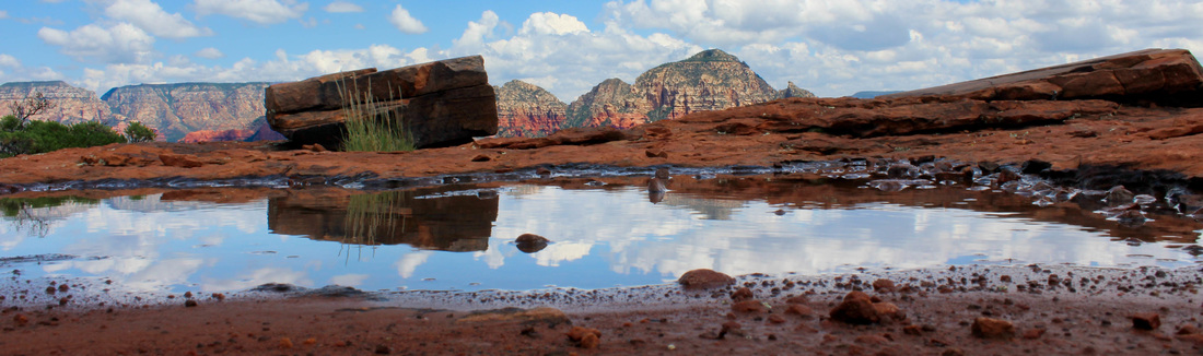
 Kimberly took the landscape above.
We started the morning with a great hike up Bear Mountain. The gps did not agree with the trail map but we were on the clear easy to follow trail. Made it to the top and had some great views but not to the summit, which was a higher part of the mesa. Our trail did not seem to lead that way. No worry as the top of the cliffs was the reward. It was fun to see a black hawk cruising below us, then a tour helicopter below us as well. The chopper did gain altitude and fly about over our heads. Down from Bear and across the street to Doe Mountain. Does is a quick, easy climb to another mesa with great views. The cliff seems to overhang the valley so it feels dramatic. We found some puddles and I shared an old Galen Rowell trick with Kimberly and she made some really great "lake" images like the panoramic image above. We got back from these hikes with time to spare and decided to try a hike from an old guidebook that had already led us astray a couple of times. This time we used the odometer to find a dry wash (the wrong one) that should have led to the Lost Canyon Ruins - a name the guidebook author made up and is not used on any maps we could find. I liked this location because we got to go down what the guidebook called the worst 4WD road in the area. I offered Kimberly a turn at driving and she refused. The wash was full of bowling ball size river rocks, most just as round. At 0.6 miles we were supposed to be in a canyon. At 0.5 there was no canyon in sight. A rock rolled under my foot and my ankle twisted with a loud pop. Search for ruins aborted. I wanted to get back to the Land Rover before my ankle swelled and got worse. Kimberly helped me limp back and found a much smoother trail that avoided the rocky path. When we reached the road she took off with the keys. A few minutes later here comes the Land Rover with my hero at the wheel. Kimberly drove out so smoothly you would think she did this all the time. She kind of put my 4WD driving skills to shame - except maybe I like hitting all the big bumps? Usually, at least. Smooth was a lot better with a sore ankle. My lack of coordination cut the day short, if 6 miles of hiking including 2 climbs well over 1,000 feet each, a 1/2 mile of limping, and 4 miles of rock crawling counts as a short day. I highly recommend the Bear / Doe combination! GPS link
0 Comments
We took Schnebly Hill Road up to the Cowpies trailhead and hiked up to the Hangover trail, which led us over a saddle and along a fairly narrow trail which hung over the valleys below. That kind of hangover. This was a really great hike! OK, they all were. We had made some detours looking for hidden ruins and lesser known arches with no luck at all. Went around and got a different angle of the mesa top across the way and there were 4 arches!
Palatki and Honaki Ruins planned for our morning. We stayed longer and it filled more of our day. I actually drove down to Honaki the afternoon before but the gate had closed. She got a cool shot of a 'face' in a rock above that reminded us of what Jesus' face might have looked like on the cross.
I visited Palatki alone years ago, long before it was a protected site. An old guy said, "So you like the old ruins? Take this old dirt road till you see a double-track rut by a...". It was a bit hard to find and felt way out in the boonies. I parked where his directions indicated and took a little trail. When I came to the bent over tree and I went under and there it was. I carefully entered what I remember as being a 3-story room and took a photo looking back out one of the upper windows. I also climbed a rock fin nearby for a photo. You can't do that sort of thing now. It is protected and you have to go on guided tours and it is a good thing. Though I was outrageously careful, if enough people wander in the ruins get ruined. Back then a strange thing happened. I looked from the ruin and could clearly see my parked vehicle. Got to the vehicle and looked back. Could not find the ruin. Hiked back and forth and only convinced myself that somehow it was an "I can see you but you can't see me" place. Then I went over to the panel of pictographs and petroglyphs and found a hand print exactly the size of my own hand with the same bent index finger. All alone. Wind making noises. And sort of freaked out by seeing a 1,000 year old drawing of my own hand (or so it seemed), I decided to head back to civilization. Nowadays there is a well-graded dirt road, visitor center, and volunteer tour guides. Yet the place still gives that mysterious feeling as you wonder about what it must have been like way back then. The talk about the cave drawings is really helpful. Just a couple miles down is Honaki which is less protected and it shows. Still, it is impressive and I would not skip it. Kimberly got some really great photos of the rock art and we have posted a few of them here. When we got back and had lunch we saw monsoon rain coming. It became afternoon nap day after some Famous Pizza & Beer. Have I mentioned that place yet? So good! And I owe several photo credits to Kimberly!
We took the Soldier's Pass trail and missed the turn off for the arches. Topped out and headed around via Brins Mesa and some connecting trails back to the parking area. Wow this would be a great hike after a rain! Then we headed out Broken Arrow to Chicken Point in the Land Rover. Between the two we saw both the Devil's Kitchen and Devil's Basement sinkholes. Despite the names assigned, the whole day was filled with the glory of God's artistry in nature. The first hike of the week in Sedona was nice. There is a resort along the first mile or so which limits the wilderness experience, but it gets more remote further along. We had an old guidebook directing us to a side trail up to some ruins but never found the old trail. Up near the box of the canyon it became pretty heavily forested with red cliffs above.
Here is a link to the GPS data from the hike. Taking our time heading out to Sedona, we stopped for a brief visit at Tonto Natural Bridge near Payson. The hosts in the visitor center mentioned to watch for and not get too close to the javelina. Turns out she was right behind the building and had a friendly disposition.
We picked one of the trails down to the natural bridge. It is a lot bigger than I expected! More like a double-openening cave. The hike drops a couple hundred feet perhaps. Not long and you'll stop for photos. The hike back up is just enough to get a little blood pumping to flush the seat-of-the-car feeling out of your glutes. It was a fun little stop and really could have filled half a day here easily. But we hit the road and finished the scenic route to Sedona. OK, they are all scenic. The roundabout route. |
AuthorJohn Stapleton ArchivesCategories |

- home
- This Week's New Listing
- 8703 Bridgeport
- 1200 Boerne
- 1900 Little Elm #130
- 7812 Dakota
- 22007 Nameless
- 25600 Fawn
- Full Move
- Help Us Buy a Home
- Come Sell Our House
- Reviews
- Austin Realty Blog
- New Clients Please Watch
- SOLD on Glass Mountain
- Another sale on Old Mill
- SOLD on Cerro Ct
- Buy before Selling
- SOLD on Clover Ridge
- SOLD another on Old Mill
- Sold on Winecup
- Steps in Selling a Home
- Steps in Buying a Home
- Another Sold on Old Mill
- Sold in Mason Ranch
- Sold in Spicewood / Balcones
- Oak Knoll 2.6 Acres
- Sold on Legend Hills
- SOLD on Paint Brush Trail
- SOLD on Cedarcliffe
- Call Back Schedule
- SOLD on Pomegranate Pass
- SOLD Lime Creek Land
- Recently Bought & Sold
- Texas Real Estate Commission Information About Brokerage Services
- Real Estate Marketing Photos
- Travel Blog
- Cabinet Painting
- Milburn Park
- Lakeline Metro Rail
- Hill Country
- Contract Class
- Big Bend Adventure
- Lake Cedar Park
- Search
- Make Ready Consultation
- Safety During Showings
- Vendor Recommendations
- Working By Referral
- Mortgage Pre-Approval Process
- Live MLS Search
- Cancel Insurance
- Make an Offer
- Mulitple Offers
- Counter Offers and Negotiation
- Contract on a Home!
- Negotiate Concessions
- 80
- Pending Without Option
 RSS Feed

|
SubscribeJoin our mailing list today!
John
|